


AviNavi, navigation for pilots
BBFlight LLC
Descrição do AviNavi, navigation for pilots
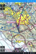
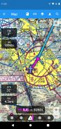
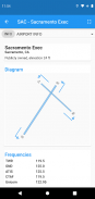
A navegação da aviação é simples e acessível. Todas as cartas VFR, IFR de baixa altitude e cartas de aproximação por instrumentos para o território continental dos Estados Unidos, com planejamento de voo completo, incluindo suporte para navegação aérea. Sobreposições para Nexrad, METARs e AIRMETS / SIGMETS melhoram a segurança do vôo, e informações detalhadas do aeroporto (pistas, frequências, combustível, clima) estão ao seu alcance.
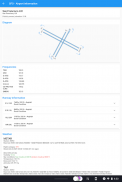
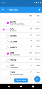
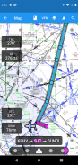
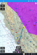
Use o mapa móvel para pesquisar ou selecionar um aeroporto, VOR, NDB ou interseção e iniciar a navegação direta ou adicionar ao plano de vôo. Em alternativa, introduza o plano de voo em texto, por ex. KPAO SUNOL V334 SAC KSAC carregará o plano de vôo completo, incluindo todos os pontos de navegação aérea.
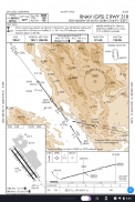
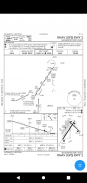
Os gráficos de abordagem de instrumentos incluem o diagrama do aeroporto, STARS, DPs e mínimos, bem como a legenda.
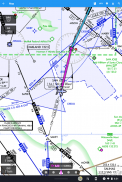
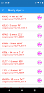
Os aeroportos próximos são mostrados em verde ou vermelho para indicar se esses aeroportos podem ou não ser alcançados em um planeio sem vento.
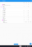
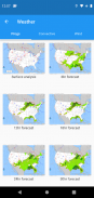
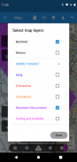
METAR, TAF, AIRMET, SIGMET, Prog charts, Convective Outlook e Wind estão disponíveis como informação gráfica e / ou textual. METARs e AIRMETS / SIGMETS podem ser sobrepostos no mapa usando o botão Layers. As informações do aeroporto mostram METARs e TAFs em inglês simples, e gráficos Prog, Convective Outlook e Wind gráficos para diferentes tempos e altitudes estão disponíveis como gráficos de tela inteira.
AviNavi requer uma assinatura mensal ou anual, após um período de teste gratuito.
AviNavi, navigation for pilots - Versão 4.5.7
(08-01-2024)
AviNavi, navigation for pilots - Informações do APK
Versão do APK: 4.5.7Pacote: com.bbflight.avinaviÚltima versão de AviNavi, navigation for pilots
Outras versões


Apps na mesma categoria


